NEWS | SOFTWARE | SHEET
Using a Surveying Dumpy Level: A Step-by-Step Guide
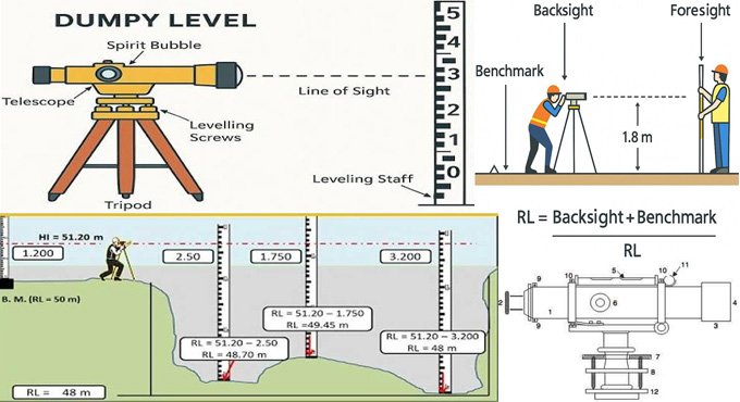
A dumpy level is a surveying levelling instrument that has been used to determine the elevation of landmasses. The dumpy level consists of a telescope tube that has been firmly secured in two collars and fixed by adjusting the screws to the stage. The telescope used in the dumpy level can be rotated only in a horizontal plane and helps to establish the relationship between two or more points on a horizontal surface.
The dumpy level helps to achieve the relative height and distances between the different surveying land locations. In addition, the surveyor can also determine the close distance between the different surveying land locations by using the dumpy levels.
Discuss the different components of the dumpy levels in surveying
Eyepiece
The eyepiece of the dumpy level helps to magnify the image and adjusts the crosshairs for a clearer view.
Focussing Screw
This part of the dumpy level is used to move the internal lens forwards and backwards, and this process continues until the object image becomes sharp.
Diaphragm
This metal ring of the dumpy level helps to hold the crosshairs that have been aligned with the levelling staff, thus helping to get more precise readings.
Cross Bubble Tube
This part of the dumpy level has been placed perpendicular to the longitudinal bubble, which helps to ensure that the instrument can level across the horizontal axis.
Longitudinal Bubble Tube
This part of the dumpy level has been used to check if the instrument has been levelled lengthwise or not.
Object Glass
The object glass helps to collect light from the object that has been viewed, and it helps to form a real image of the object.
Shade
This part of the dumpy level helps to reduce the glare from sunlight.
Circular Compass
This part has been implemented in the dumpy level to help with the orientation and alignment.
Foot Screws
The foot screws have been used to bring the instrument to an accurate horizontal position.
Tribrach
This part helps to connect the telescope assembly to the levelling screws.
Levelling Head
This part of the dumpy level helps to hold the foot screws and can also connect the tripod head.
Tripod Stand
This part helps to support the entire setup of the dumpy level.
Working procedure of dumpy levels in surveying
- At first, the dumpy level is mounted securely on a tripod. Next, the bubble in the spirit level is adjusted by using the foot screws.
- In the next step, the engineer peers through the telescope to get the reading from a levelling staff that has been held vertically at the point of measurement.
- Two types of readings have been taken by using a dumpy level, which are Backsight (BS) reading on the known benchmark and Foresight (FS) reading on the target location.
- In the next step, the difference between the elevations has been measured, which allows the engineers to determine elevation differences between points on a construction site.
Understanding the advantages of dumpy levels in surveying
Easy to use
The design of the dumpy level is user-friendly, which does not require complex setups or training to operate the dumpy level. Surveyors can easily learn the process of operating the dumpy level, making it a more accessible tool for construction projects.
Helps to achieve proper horizontal levelling
The dumpy level helps to achieve accurate horizontal reference lines, which helps to ensure that the structures and features have been built on level ground; thus, the dumpy level helps to minimise uneven construction issues and imbalanced foundation issues.
Provides more cost-effective solutions
The dumpy level is affordable, which is perfect for those smaller construction projects that do not demand extreme precision of high-end instruments.
Provides clear and direct readings
There are clear and well-defined crosshairs within the telescope of the dumpy level, which helps to achieve more accurate readings of staff measurements.
Helps to get a robust and durable design
The dumpy levels can resist the rugged outdoor conditions. The sturdy construction of the dumpy level allows it to endure the rigours of the construction site.
Helps to achieve versatile terrain compatibility
The dumpy level can be used in different terrains, for example, gentle slopes, flat areas, and uneven surfaces and provides accurate measurements for the terrains.
Appropriate for small to medium-scale projects
In the case of the constrcuion projects that do not require high precision or advanced surveying techniques, the dumpy level can be an appropriate choice. The dumpy level is ideal for foundation levelling tasks, site preparation tasks and basic road construction tasks.
Learn about the applications of dumpy level surveys in the construction industry
Used in height difference measurement process
The dumpy level has been employed to estimate the vertical differences between the backsight and foresight reading points, which enable the surveyors to estimate the relative heights more accurately.
Used in construction surveying
The dumpy level has been used in construction surveying methods to establish the reference points and verify the different levels during the construction process. The dumpy level also helps to transfer the designed elevations from plans to the actual ground.
Used in drainage, grading and surface levelling
The dumpy level is important to grade roads, canals, landscapes and pipelines, which helps to ensure accurate slopes in the drains and also ensures proper drainage flows.
Used in landscaping and agricultural works
The dumpy level has also been used in designing terraces and irrigation systems, which helps to ensure proper distribution of water in farming or landscape layouts.
Used in the creation of topographic profiles and contours
The dumpy level is also used in the topographic surveying process, which helps to develop contour maps by determining the elevation points throughout the construction site.
Used in roads and infrastructure projects
The dumpy level also helps to guide the alignment and scope controls of the roads, drainage channels and railways, which helps to ensure that the construction infrastructure will meet the planned gradients.