NEWS | SOFTWARE | SHEET
Types of Leveling Methods used in Surveying
Levelling and surveying refers to the operations that are required for comparing the height of points on the earth's surface. In this case, the whole series of heights has been given relative to the plane where the plane is known as a datum. In the context of topographical work, datum has been used in the mean level of the sea as it helps to make the international comparison of the heights.
The value of the mean sea level can be determined by making averages of the elevations of high and low tides over a long period of time. In this context, the vertical height of points has been refers to the level. The process of determining the differences in the elevations refers to the levelling which is a fundamental process in the topographical surveys.
Benefits of levelling
- Levelling is used for understanding the topography of the soil. Surveyors are able to create contour maps by measuring the ground’s height at different levels which helps to show the shape of the land. The information shown in the contour map plays an important role in planning the use of land, making engineering projects and environmental management.
- In the case of construction projects, the development of the structures can be done by doing levelling. This process is used by the builders to make sure that the foundation of the construction structure is level and stable thus ensuring the safety and durability of the construction structure.
- Levelling is also important to centerline a road which helps to ensure that the road is safe for the drivers. The height of the roads at various points along the road has been also determined by the surveyors by applying the following techniques. Thus the surveyors are allowed to make a plan for the road which considers the elevation changes and helps to ensure that the road surface will be smooth and even.
Main applications of levelling in surveying
- It is used to estimate and design numerous civil engineering projects such as bridges, canals, and other projects. Levelling is also needed to survey the routes and make alignments of bridges or highways.
- While earthwork is required such as cutting or filling, it is necessary to do levelling.
- Pipeline survey is another important application of levelling which helps to determine the routes and also helps to provide optimum slope for achieving the smooth flow inside the pipelines.
- The preparation of contour maps and topographic maps can also be done by levelling in surveying.
Different methods or types of levelling in surveying
Direct levelling
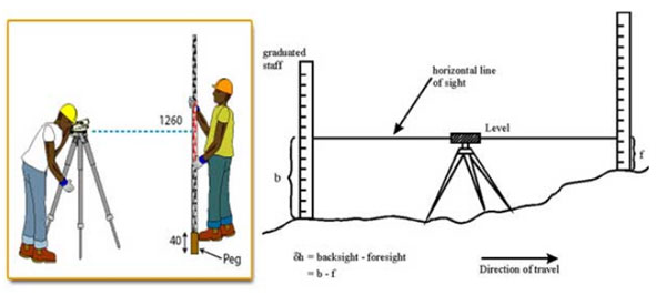
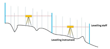
Direct levelling is one of the common methods of levelling in surveying. In this type of levelling, measurements have been observed from the levelling instruments directly. On the basis of the positioning of the levelling instruments and the observation points, direct levelling has been divided into different types which are:
Simple Levelling
In this case, the levelling instrument has been placed between the points in which elevations have been found. In each of the points, the levelling rods are placed and those rods are sighted through the levelling instruments. This type of direct levelling method is only conducted in the case of points that are nearer without the presence of any obstacles.

Differential Levelling
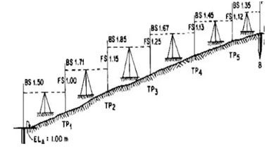
This type of direct levelling method has been conducted in case the distance between two points is greater. In differential levelling, the number of the inner station is located and the levelling instruments have been shifted to each of the stations which is used to observe the elevation of inter station points. Therefore, the difference between the original two points has been determined.
Fly Levelling
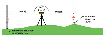
This levelling method has been conducted in the case of the benchmark is far from the workstation. In this case, a temporary benchmark has been located at the workstation which has been located on the basis of the original benchmark.
Profile Levelling
This type of levelling method is adopted to discover the elevation of points along roads, rivers, or rails. In this levelling method, the readings of intermediate stations have been taken. In addition, the reduced level of each station has been found in this context.
Reciprocal Levelling
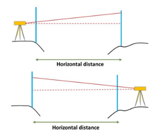
In the case of locating the levelling instrument in between the inner visible points, this type of direct levelling method has been performed. This reciprocal levelling method has been performed in the case of rivers or ponds in which the levelling instrument has been placed nearest to the first station and has been sighted towards the second station.
Precise Levelling
This levelling method is similar to differential levelling though, higher precision is required in this type of levelling technique. This higher precision can be achieved by performing the serious observation process. In this method, an accuracy of 1 mm per 1 km can be achieved.
Trigonometric Levelling
In this type of levelling method, the difference between a point or the elevation of points has been estimated from the vertical angles and the observed horizontal distances in the field which is referred to as trigonometric levelling.
This trigonometric levelling is also known as indirect levelling.

Barometric Levelling
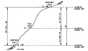
This type of levelling method has been used for measuring the atmosphere at any altitude. The atmospheric pressures at two different points have been observed in this levelling method on the basis of the vertical differences between those two points. This method of levelling is used rarely as this is a rough estimation technique.
Stadia levelling
This type of levelling technique is the modified version of trigonometric levelling. In this type of levelling technique, the tacheometer principle has been used for determining the elevation of points.
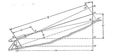
In this method of levelling, the line of sight has been inclined from the horizontal. This levelling method is more appropriate and accurate for surveying in hilly terrains.
